A Prosper Police Department drone flew for 12 minutes over Prosper on Tuesday 13 October 2026 at 4:58 pm CDT, logged purpose: Other.
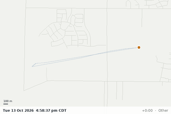
12 min airborne, from 4:58 pm to 5:10 pm CDT.
4.4 km flown along the drawn path (first and last 200 m removed; 4.4 km before the clip).
2.2 km between the two farthest points of the drawn path.
Other is the purpose the agency logged, grouped into this site's classes.
Tuesday and the flight took off in the afternoon (noon to 6 pm).
PROSPTXPD-261013-0004 is the flight id in the agency's record.
On the map
The same drawn path over a street map. Zoom freely; the first and last 200 m of the flight are not drawn anywhere on this site.
Flight path; takeoff and landing removed
How this page is made
- Nothing that landed in the last 48 hours is counted, listed or drawn.
- Drawn paths are simplified to 10 m and lose their first and last 200 m; flights too short to keep an interior are counted but not drawn.
- The record's free-text description is never read into a page. Flights whose stated purpose names a domestic, sexual-assault, kidnapping, welfare, mental-health or juvenile matter are counted in totals and appear in neither the flight list nor on the map.
- Purposes are the agency's own words, grouped into classes by a committed lookup table; unmatched values are "Other" and blank ones "Not stated".
- Times are converted to the agency's clock through the IANA zone database, never a fixed offset.
- The animation times the path at constant speed between the recorded takeoff and landing; the feed carries no per-point timestamps.
- The raster basemap is Census TIGER road lines (public domain) for the feed's county; a flight outside it, or outside the United States, is drawn on a plain ground. No tile service is rasterised.
- The flight's own free-text description, the operator, and the agency's external case number are not shown.
Corrections and questions: file an issue in the korvid-labs repository (demo).